Nowra Riverfront Precinct Activation
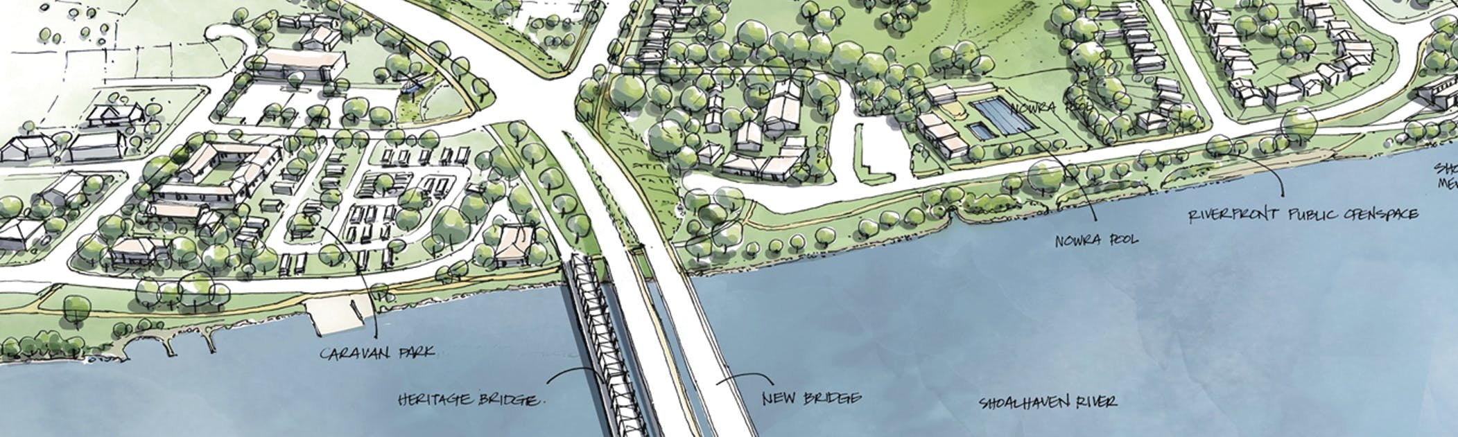
The Nowra Riverfront Precinct provides a significant opportunity to shape the future of Nowra and strengthen its role as the civic, community, tourism, and recreational hub for the Shoalhaven region. Nowra’s Riverfront Precinct is bound by Scenic Drive to the north, Hawthorn Avenue to the east, Hyam Street and Graham Street to the south and Shoalhaven Street to the west (outlined in yellow on the map).
Stay Informed
To follow this project and receive updates, subscribe through the ‘Stay Informed’ tool on this webpage.
-
Nowra Riverfront Rezoning Proposals finalised
Share Nowra Riverfront Rezoning Proposals finalised on Facebook Share Nowra Riverfront Rezoning Proposals finalised on X (formerly Twitter) Share Nowra Riverfront Rezoning Proposals finalised on Linkedin Email Nowra Riverfront Rezoning Proposals finalised link
The New South Wales Government has announced the approval of two major rezoning proposals in the Nowra Riverfront Precinct, paving the way for the delivery of new social, affordable and private homes.
The NSW Department of Planning, Housing and Infrastructure (DPHI) and Homes NSW have worked in partnership with Council on the two separate rezoning proposals, to enable a greater diversity of housing across 3.4 hectares of waterfront land in the western portion of the precinct, as well as within the Mandalay Avenue Sub-Precinct.
The Nowra Riverfront Precinct rezoning amends planning controls under Shoalhaven Local Environmental Plan (LEP) 2014 at the Scenic Drive, Hyam Street and Bridge Road sub-precincts. The site-specific provisions will facilitate development of up to 377 new homes and guide commercial and residential development consistent with the overall precinct master plan.
The Mandalay Avenue Sub-Precinct rezoning will enable the delivery of approximately 537 dwellings within the Mandalay Avenue Sub-Precinct, including a minimum of 30 per cent social and affordable housing across Homes NSW land.
Read the NSW Government’s Media Release to learn more about the finalisation of the rezoning proposals.
Background:
During a visit to Nowra in March 2025, NSW Premier Chris Minns announced both rezoning proposals would be fast-tracked through the NSW Government’s streamlined, State Significant Rezoning pathway.
The rezoning proposals were exhibited for community feedback by the NSW Government in November-December 2025.
Separately, in January 2025, Prime Minister Anthony Albanese committed $5 million in Australian Government funding, under the Regional Precincts and Partnerships Program (rPPP) to assist Council to finalise the Open Space Master Plan and prepare detailed designs for essential roads, paths, drainage and recreation facilities for the broader Nowra Riverfront Precinct.
Next steps:
Council is working to finalise the remaining technical studies that will inform the future Development Control Plan (DCP) chapter for the Nowra Riverfront Precinct, as well as a supporting infrastructure delivery strategy and sewer servicing investigations. The DCP chapter will support the rezonings and guide future development in line with the Precinct vision.
This work will progress alongside the detailed design of new central open space, road access, paths and drainage funded under the Federal Government’s Regional Precincts and Partnerships Program (rPPP), supporting future housing in the Precinct and across the City Centre.
-
Outcome Snapshot: Community survey on the Open Space Masterplan (OSMP)
Share Outcome Snapshot: Community survey on the Open Space Masterplan (OSMP) on Facebook Share Outcome Snapshot: Community survey on the Open Space Masterplan (OSMP) on X (formerly Twitter) Share Outcome Snapshot: Community survey on the Open Space Masterplan (OSMP) on Linkedin Email Outcome Snapshot: Community survey on the Open Space Masterplan (OSMP) link
Thank you to everyone who took part in consultation on the Open Space Master Plan for the Nowra Riverfront Precinct.
Participation
- Over 3000 people visited the Nowra Riverfront Precinct Activation project page
- Over 900 people downloaded the OSMP
- 99 people contributed feedback on the OSMP community survey
Overall Sentiment
The community expressed strong support for the direction of the Open Space Master Plan:
- Many respondents strongly support improved walking and cycling connections
- A majority agreed that the OSMP’s proposed activities reflect their needs and interests
- Overall satisfaction was generally positive, though some participants raised concerns around feasibility, flooding andContinue reading
-
Have your say on the future of the Nowra Riverfront Precinct - Open Space Master Plan (OSMP)
Share Have your say on the future of the Nowra Riverfront Precinct - Open Space Master Plan (OSMP) on Facebook Share Have your say on the future of the Nowra Riverfront Precinct - Open Space Master Plan (OSMP) on X (formerly Twitter) Share Have your say on the future of the Nowra Riverfront Precinct - Open Space Master Plan (OSMP) on Linkedin Email Have your say on the future of the Nowra Riverfront Precinct - Open Space Master Plan (OSMP) link
Council’s Nowra Riverfront Precinct Open Space Master Plan is now on exhibition. Funded by the Australian Government, the plan sets out a vision to bring the riverfront to life as a vibrant, inclusive and sustainable destination for the community.
Informed by extensive community engagement and Designing with Country principles, the plan includes a revitalised Paringa Park, new open spaces and play areas, an events space near the Aquatic Centre, shared walking and cycling paths, improved parking, and a new wetland to help manage stormwater and flooding while creating places to relax and connect with nature.
The Open Space Master Plan will sit alongside new residential and mixed‑use development, delivering a range of housing options and hospitality opportunities as the precinct continues to grow.
Share your feedback via the Get Involved survey by Tuesday 24 March 2026
-
Feedback sought on rezoning proposals
Share Feedback sought on rezoning proposals on Facebook Share Feedback sought on rezoning proposals on X (formerly Twitter) Share Feedback sought on rezoning proposals on Linkedin Email Feedback sought on rezoning proposals link
The NSW Department of Planning, Housing and Industry (DPHI) is now seeking feedback from the Shoalhaven community on two rezoning proposals within the Nowra Riverfront Precinct.
The first proposal relates to the proposed rezoning of 3.4 hectares of waterfront land within the western area of the precinct. The second, separate rezoning proposal lodged by Homes NSW would enable delivery of approximately 537 dwellings in the Mandalay Avenue Precinct. More details on each of the proposals is provided below.
A community drop-in information session will be held at the Shoalhaven Entertainment Centre on Thursday 27 November from 4:00pm to 6:30pm.
Rezoning Proposal 1 (marked yellow, orange and red on the map)
This proposal seeks to amend Shoalhaven Local Environmental Plan 2014 (LEP) to increase the maximum building height at the Scenic Drive, Hyam Street and Bridge Road sub-precincts. If approved, the rezoning would facilitate development for up to 377 new homes and associated commercial/retail premises, to activate the riverfront into a community, cultural and recreational hub.
This is a State-led rezoning (SLR) being undertaken in collaboration with Council and the Nowra Riverfront Advisory Taskforce under the State Significant Rezoning Policy.
View the Explanation of Intended Effect and supporting documents and provide your feedback to the NSW Government by Wednesday 17 December 2025.
Enquiries should be directed to the NSW Government’s State-led Rezoning Team.
Rezoning Proposal 2 (marked in blue on the map)
This rezoning proposal has been lodged by Homes NSW to enable the delivery of approximately 537 dwellings within the Mandalay Avenue Sub-precinct. At least 30 per cent of the new dwellings delivered by Homes NSW will be social and affordable housing.
This is a State Assessed Rezoning Proposal under the NSW Government’s Prioritising rezonings that deliver social and affordable housing program.
View the Mandalay Avenue Precinct Planning Proposal and provide your feedback to the NSW Government by Wednesday 17 December 2025.
Enquiries should be directed to the NSW Government’s State-Assessed Rezoning Team.
-
Nowra Riverfront Precinct State Assessed Rezoning Announcement
Share Nowra Riverfront Precinct State Assessed Rezoning Announcement on Facebook Share Nowra Riverfront Precinct State Assessed Rezoning Announcement on X (formerly Twitter) Share Nowra Riverfront Precinct State Assessed Rezoning Announcement on Linkedin Email Nowra Riverfront Precinct State Assessed Rezoning Announcement link
On 4 March 2025, the Minns Government, in partnership with Shoalhaven City Council, announced that two major housing projects in the Nowra Riverfront Precinct will be fast tracked for development.
Nowra’s Riverfront Precinct has been identified for major urban rejuvenation as 3.4 hectares of waterfront land will be rezoned for increased residential density under the State Significant Rezoning Policy. Building Height variations are proposed across the Nowra Riverfront Precinct which will allow for an estimated 270 new homes to be built. This development supports the strategic goals set out in the Illawarra Shoalhaven Regional Plan 2041 to stimulate the area’s reactivation and economic growth.
The NSW Government will now progress the project through a streamlined State Rezoning Pathway. This will allow the Department of Planning, Housing and Infrastructure to finalise the project’s technical studies in collaboration with Shoalhaven City Council, to inform the Planning Proposal. The Department will play a central coordinating role with stakeholders and enable the acceleration of this significant Precinct.
At the same time, Homes NSW is progressing with a proposal to rezone the Mandalay Precinct, to develop up to 380 new homes on the site, delivering a mix of social, affordable and private housing.
This activation will leverage recent NSW Government investment in the Shoalhaven Hospital redevelopment, upgrade of the Princes Highway and delivery of the new Shoalhaven River Bridge, as well as Shoalhaven City Council’s proposal for public improvements along the foreshore.
These are exciting announcements for the Nowra Riverfront Precinct and will be progressed alongside the planning for the activation of the Nowra Riverfront Precinct and development of a Masterplan for the Precinct’s Activation.
Vie the Media Release here: https://www.planning.nsw.gov.au/news/650-new-homes-shoalhaven-part-plans-nowra-riverfront-precinct
Stay Informed
To follow this project and receive updates, subscribe through the ‘Stay Informed’ tool on this webpage.
-
Council successful in $5 million grant application for the Nowra Riverfront Precinct.
Share Council successful in $5 million grant application for the Nowra Riverfront Precinct. on Facebook Share Council successful in $5 million grant application for the Nowra Riverfront Precinct. on X (formerly Twitter) Share Council successful in $5 million grant application for the Nowra Riverfront Precinct. on Linkedin Email Council successful in $5 million grant application for the Nowra Riverfront Precinct. link
On 14 January 2025, the Albanese Government awarded Council $5 million in funding, under the Federal Government’s Regional Precinct and Partnership’s Program. The funding will enable Council, in collaboration with the NSW State Government, to continue work on planning for the activation of the Nowra Riverfront Precinct and develop a Master Plan for the Precinct’s Activation.
The Nowra Riverfront Precinct Activation project will realise a long-held community aspiration to reconnect Nowra’s city centre with the Shoalhaven River while elevating Nowra as the region’s civic, community, tourism and recreational hub.
Thoughtful urban renewal and public realm improvements will create an activated and connected place for residents, workers and visitors. The Precinct’s vision features a central flagship park and leisure facilities, restored natural areas, improved accessibility, affordable housing and repurposing of the historic Nowra Bridge. First Nations knowledge and culture will be embedded in the Precinct design. Early delivery of public realm improvements will stimulate investment and renewal of surrounding built form.
The funding will enable the completion of remaining planning investigations, the finalisation of the Precinct masterplan and the preparation of designs for key enabling infrastructure (new central open space/park, new road access and required drainage infrastructure). This work will build upon the Nowra Riverfront Activation Plan, which was developed with direct input from the local community.
View the Media Release here: The Albanese Government delivering $5 million for Nowra Riverfront Precinct | Prime Minister of Australia
Stay Informed
To follow this project and receive updates, subscribe through the ‘Stay Informed’ tool on this webpage.
-
 Background, History and Scope
- Where is the Nowra Riverfront Precinct?
- What work has been done so far in planning for this precinct?
- What infrastructure funding will be made available to support new housing in the Nowra Riverfront Precinct?
- What is the Nowra Riverfront Advisory Taskforce (NRAT)?
- What consultation has been undertaken to date?
-
NSW Government State Led-Rezoning Proposal
- What is the NSW Government’s State Significant Rezoning Policy and why has the Nowra Riverfront Precinct been included?
- Why is the State Assessed Rezoning Proposal focusing on the Nowra Riverfront Precinct land, west of the Princes Highway?
- What is the difference between the Federal Government’s announcement of $5M funding and the NSW Government’s State Assessed Rezoning Proposal?
- What is the Mandalay Avenue Precinct Proposal?
- Why will the Nowra Riverfront Proposal be managed by the Department of Planning, Housing and Infrastructure (DPHI)?
- What consultation will occur as part of the State Assessed Rezoning Proposal?
-
Nowra Riverfront Precinct – Open Space Master Plan (OSMP)
-
Nowra Riverfront Precinct Strategic Direction and Proposed Planning Controls Report (2018)
-
 Nowra Riverfront Entertainment and Leisure Precinct - Final Report
-
Draft Nowra Riverfront Entertainment Precinct Proposed Planning Controls Report
-
Draft Nowra Riverfront Entertainment Precinct Strategic Direction Review Analysis Report
-
Nowra Riverfront Report to Development Committee – 11 September 2018
-
Nowra Riverfront Resolution of Development Committee – 11 September 2018
-
-
Nowra Riverfront Precinct Explanation of Intended Effect (NSW Government, 2025)
-
 Nowra Riverfront Precinct Integrated Transport Plan
-
Nowra Riverfront FIRA Executive Summary
-
Nowra Riverfront FIRA Full Report
-
Nowra Riverfront FIRA Map Compendium
-
Nowra Riverfront Explanation of Intended Effect (4.68 MB) (pdf)
-
Nowra Riverfront Urban Design Report (30.4 MB) (pdf)
-
Nowra Riverfront Economic Feasibility Study (3.87 MB) (pdf)
-
Nowra Riverfront Detailed Integrated Traffic and Transport Plan (12.1 MB) (pdf)
-
Nowra Riverfront Non-Indigenous Heritage Review (10.7 MB) (pdf)
-
Nowra Riverfront Aboriginal Objects Due Diligence Assessment (13.4 MB) (pdf)
-
Nowra Riverfront Final Constraints Assessment Report (37.9 MB) (pdf)
-
Nowra Riverfront Proposed LEP Maps (8.95 MB) (pdf)
-
Nowra Riverfront Integrated Water Cycle Management Plan (19.2 MB) (pdf)
-
-
Community Engagement Reports

-
Shoalhaven City Council
Phone 1300 293 111 Email council@shoalhaven.nsw.gov.au