
Nebraska Estate Planning Proposal (rezoning)
The Nebraska Estate subdivision was registered in 1922. The land remained undeveloped bushland without infrastructure and has been zoned rural since the first planning controls were introduced in 1964. This zoning has generally prevented the lots from being developed. In 1992, Council resolved to investigate rezoning several paper subdivisions in the Jervis Bay area, subject to the owners meeting all costs associated with rezoning the land and providing the necessary infrastructure. Nebraska Estate is the last of these to be resolved.
Proposed changes to zoning within Nebraska Estate
Council is proposing changes to the Shoalhaven Local Environmental Plan (LEP) 2014 to rezone land within the Nebraska Estate.
The Estate’s sensitive environmental land is proposed to be rezoned from RU2 Rural Landscape to C2 Environmental Conservation, while the least constrained land (northwestern sector) is proposed to be rezoned to R5 Large Lot Residential and two less-constrained areas (eastern and northeastern sectors) are proposed to be rezoned to C4 Environmental Living. See map below.
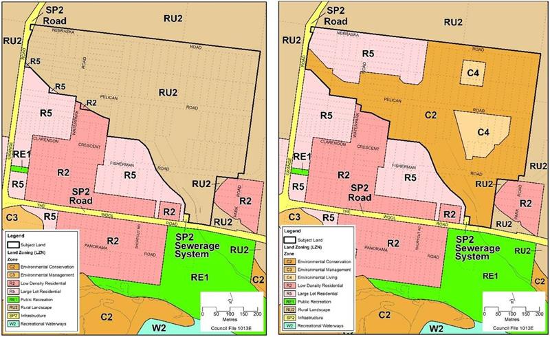
Figure 1 - Land Use Zoning Map (LZN) - Existing (left) and proposed (right)
The proposed changes will also allow for 17 new dwellings to be approved within the proposed R5 and C4 land, once essential infrastructure has been provided. A site-specific development control plan (DCP) will also need to be prepared before new homes are approved in the Estate.
The NSW Department of Planning, Housing and Infrastructure (DPHI) issued a Gateway approval in March 2024, allowing Council to publicly exhibit the Nebraska Estate Planning Proposal.
Community feedback on the proposed changes to the LEP will be sought when the Nebraska Estate Planning Proposal is publicly exhibited in early 2026. A drop-in information session will be held during the exhibition. Details of the exhibition and drop-in information session will be provided closer to the date.
-
Community Consultation Snapshot
Share Community Consultation Snapshot on Facebook Share Community Consultation Snapshot on X (formerly Twitter) Share Community Consultation Snapshot on Linkedin Email Community Consultation Snapshot link

Thank you to everyone who took part in our recent consultation about the Nebraska Estate Planning Proposal.
Public exhibition
The proposal was on public exhibition from 14 January to 25 February (42 days), which exceeded the 20 business days required through the Gateway process.Community participation
A community drop‑in session was held on 21 January, and we enjoyed speaking with the local landowners who attended on the day.Submissions received
We received 8 written submissions, including:- 3 from members of the broader community
- One from a planning consultancy on behalf of a landowner
- 4 from individual landowners.
We also received one submission from a government agency.
Online engagement
During the exhibition period, 288 community members visited the project page, and the project documents were downloaded 182 times.We appreciate your input. It will be carefully considered and summarised to form part of a post-exhibition report to Council in the coming months. We will continue to update you here about the next steps for this project.
-
Reminder – Opportunity to provide feedback closes on 25 February
Share Reminder – Opportunity to provide feedback closes on 25 February on Facebook Share Reminder – Opportunity to provide feedback closes on 25 February on X (formerly Twitter) Share Reminder – Opportunity to provide feedback closes on 25 February on Linkedin Email Reminder – Opportunity to provide feedback closes on 25 February link

Anyone who wants to provide feedback on the Nebraska Estate Planning Proposal must do so by 5 pm on Wednesday, 25 February.
Feedback must be in writing and can be submitted by any of the following:
- Post: The Chief Executive Officer, Shoalhaven City Council, PO Box 42, Nowra, NSW, 2541.
- Email: council@shoalhaven.nsw.gov.au
- Website: via the link on the Documents on Exhibition page
Document Library
-
 Explanatory Document - Planning Proposal LP145.1
-
Planning Proposal - Planning Proposal LP145.1
-
Gateway Determination - Planning Proposal LP145.1
-
Frequently Asked Questions - Planning Proposal LP14.1
-
Public Notice - Planning Proposal LP154.1
-
 Aboriginal Cultural Heritage Documents
-
Biodiversity Documents
-
Planning for bushfire protection
-
Soil and water management, contamination & flooding
-
Integrated Water Cycle Assessment (13 MB) (PDF)
-
Soil and Water Management Plan - Infrastructure Subdivision Scale (298 KB) (PDF)
-
Soil and Water Management Plan - Lot Based Development (333 KB) (PDF)
-
Acid Sulfate Soil Investigation Nebraska Estate Park Road St Georges Basin (12.6 MB) (PDF)
-
Land Capability Report for Nebraska Estate The Wool Road St Georges Basin (14.8 MB) (PDF)
-
Nebraska Estate Preliminary Site Investigation (PSI) (60.6 MB) (PDF)
-
Nebraska Estate Flood Impact and Risk Assessment (FIRA) (3.99 MB) (PDF)
-
Who's Listening
-

Phone 1300293111 Email council@shoalhaven.nsw.gov.au