Clyde River Floodplain Risk Management Study & Plan
Council received grant funding from the Australian Government's Preparing Australian Communities Program – Local Stream to undertake the Clyde River Flood Study and Floodplain Risk Management Study and Plan to investigate the flood risk within the catchment.
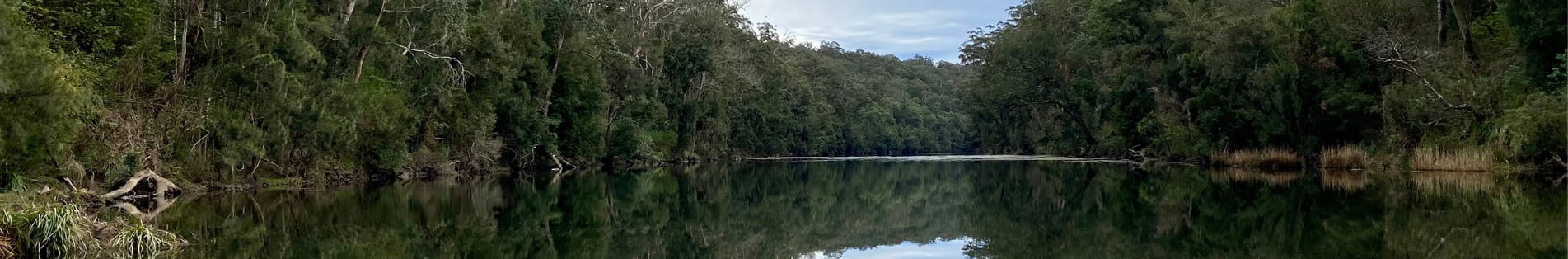
The primary study area is the 50km reach of the Clyde River from upstream of the Yadboro River confluence through the localities of Yadboro, Mogood, Morton, Brooman and Currowan to the southern boundary of the Shoalhaven City Council LGA at the confluence with the Currowan River.
This stretch of the Clyde River comprises of large areas of land owned by the NSW National Parks and Wildlife Service (NPWS) and State Forests of NSW, but with private land tenures along the river length. The focus of the flood study is predominantly privately owned land and public roads but investigating the full 50km reach length is necessary to better understand flow times and discharge relationships between different waterway crossings over the Clyde River. The catchment includes properties that quickly, for an extended period, become isolated due to inundation of existing low-level waterway crossings.
This project is being undertaken in accordance with the NSW Flood Prone Land Policy, the NSW Flood Risk Management Manual (2023) and in close collaboration with the NSW State Emergency Services (SES), the NSW Department of Planning and Environment (DPE), and other agencies and stakeholders as required.
Council has engaged a consultant, Rhelm, to assist with the preparation of the Clyde River Flood Study and Floodplain Risk Management Study and Plan. This study will improve Council’s understanding of flood behaviour and impacts on the community, and better inform management of flood risk in the study area.
Project Objectives
The objective of this study is to improve understanding of flood behaviour and impacts, and better inform management of flood risk in the study area in consideration of the available information, and relevant standards and guidelines. It aims to provide an understanding of flood behaviour and consequences in the study area across the full range of potential flood events from frequent to extreme. It involves the consideration of the local flood history, available collected flood data, and the development of hydrologic and hydraulic models.
The project also allows testing and investigating practical, feasible and economic management measures to treat existing, future and residual flood risk. The Floodplain Risk Management Study will provide a basis for informing the development of a Floodplain Risk Management Plan. The plan will document the decisions on the management of flood risk into the future. The plan will also outline a range of measures to manage existing, future and residual risk effectively and efficiently, using the investigations undertaken as part of the Floodplain Risk Management Study. This includes a prioritised implementation strategy, that details how and when measures can be implemented.
-
Initial Community Consultation Completed
Share Initial Community Consultation Completed on Facebook Share Initial Community Consultation Completed on Twitter Share Initial Community Consultation Completed on Linkedin Email Initial Community Consultation Completed link
The initial community consultation for the Clyde River Flood Study and Floodplain Risk Management Study and Plan closed on 25 August 2023. Council received a number of completed surveys. This community feedback will now be utilised to complete the draft Clyde River Flood Study and draft Clyde River Floodplain Risk Management Study and Plan.
Thank you to everyone who participated and shared your local knowledge to improve Council’s understanding of flood behaviour and impacts on the community, and also for providing feedback on potential mitigation options to be considered as part of the Clyde River Floodplain Risk Management Study and Plan.
We will continue to publish updates here as this project progresses, so keep an eye out for new information this web page. You can subscribe to receive project updates by providing your email address in the ‘Stay Informed’ box (located in the top-right corner of this screen).
-
Have Your Say - Clyde River Flood Study
Share Have Your Say - Clyde River Flood Study on Facebook Share Have Your Say - Clyde River Flood Study on Twitter Share Have Your Say - Clyde River Flood Study on Linkedin Email Have Your Say - Clyde River Flood Study link
Council has engaged a consultant to undertake a Flood Study and Floodplain Risk Management Study & Plan for the Clyde River catchment.
This survey seeks to gather your personal experiences and information on historical flood events to help us complete the flood study. Your survey responses will also assist in identifying solutions which are effective for the management of flood risk and are appropriate for the local community and environment.
Please provide your feedback by completing the Online Survey by 5pm, Sunday 25 August 2023.
You can also complete the survey, in person, at the drop-in session on Tuesday 8 August 2023 between 3pm and 7pm at the Ulladulla Civic Centre, where you can meet Council staff, local SES volunteers and our consultants working on this project.

Who's Listening
-

Phone 1300 293 111 Email council@shoalhaven.nsw.gov.au -
Phone 1300 293 111 Email council@shoalhaven.nsw.gov.au