
East Nowra Sub Arterial Road (ENSA)
Consultation has concluded
Content moved to web project page
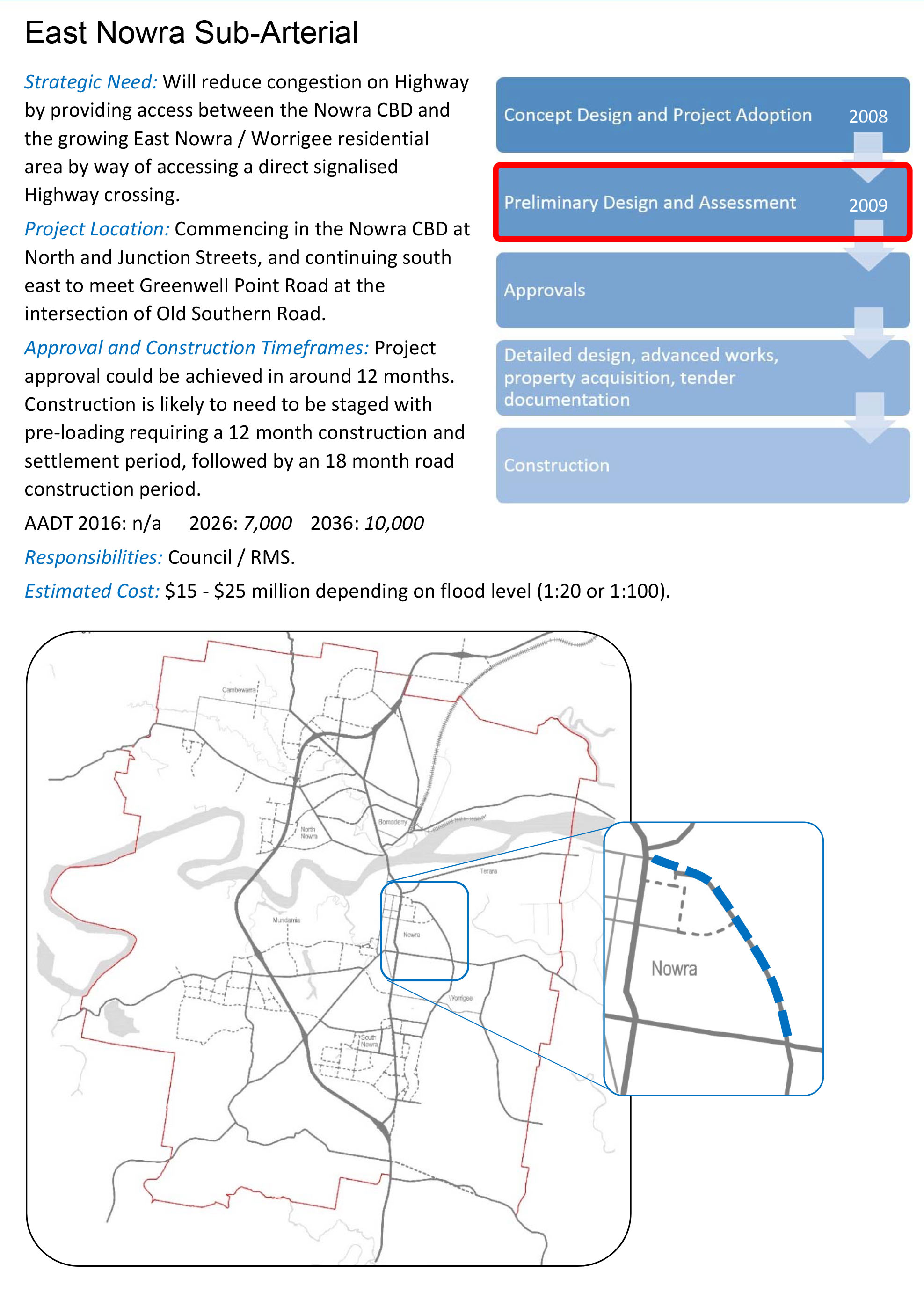
The East Nowra Sub Arterial Road (ENSA) is proposed to connect Greenwell Point Road (in the vicinity of Old Southern Road) to the Princes Highway, at North Street and Junction Street. ENSA will provide a much needed alternative connection to the highway from the East Nowra, Worrigee and coastal village areas. The link will relieve pressure along the Kalandar Street / Princes Highway route to the Nowra CBD.
This project is independent of any future Nowra Bypass which is well into the future.
Background
ENSA was initiated through Shoalhaven City Council as early as 2004, with concept designs, geotechnical and surveying work completed. Funding was not secured at the time, however, it was always deemed a viable and important project.
The project cost in 2005-2006 was estimated at between $15 - $25 million, but this figure was based on a concept design that did not take into account future studies or design changes that may be required.
In February 2008, The NSW Department of Planning endorsed the Nowra Bomaderry Structure Plan (PDF 17.8MB) which outlined major infrastructure requirements, including ENSA. In May 2009, Council’s Property Steering Committee recommended Option B as the preferred route. See public document for the recommendation information.
In May 2017, Council released the Nowra Key Road Projects Strategic Overview (PDF 2.1MB), giving a more detailed overview of ENSA, including an indicative project timeframe (as seen below). Indicative timelines are based on the original concept design only. Please see the News Feed tab below for the most recent updates.

Project Objectives
The construction of ENSA aims to:
- Reduce congestion on Kalandar Street
- Reduce congestion on the Princes Highway
- Remove traffic directly from the Highway and CBD west roads by facilitating a direct link to Stockland and Nowra High School
- Remove traffic from rural lanes such as Jindy Andy Lane and Millbank Road which have increased in traffic and have experienced high crash rates
- Improve overall network operation and safety for vehicles and pedestrians and associated environmental benefits.
Proposed Route
The original concept design route and indicative timeline (as proposed in the Nowra Key Road Projects Strategic Overview (PDF 2.1MB) is shown below. An aerial view of the route is also available in the Photo Library.
-
East Nowra Sub Arterial Road - Project Update
Share East Nowra Sub Arterial Road - Project Update on Facebook Share East Nowra Sub Arterial Road - Project Update on X (formerly Twitter) Share East Nowra Sub Arterial Road - Project Update on Linkedin Email East Nowra Sub Arterial Road - Project Update link Consultation has concluded
Shoalhaven City Council is currently undertaking detailed geotechnical work to finalise a concept plan for the East Nowra Sub Arterial Road (ENSA) project.
Council staff are in the process of considering a rather complex soil report which shows the site varies considerably. Whilst an assessment of the depth and bearing capacity of soft soil profile is yet to be completed, Council is monitoring likely project costs.
At this time with the information currently available Council estimates the projects costs are likely to exceed $50 million. As ENSA will not be funded by Council, costs of this order are bringing into question the feasibility of the project.
A decision on the future of the project is yet to be made by Council, and a report outlining Council’s options will be prepared in the coming months.
-
Project Update
Share Project Update on Facebook Share Project Update on X (formerly Twitter) Share Project Update on Linkedin Email Project Update link Consultation has concluded
September 2018
Although preliminary scope and concepts designs have been completed, a review of designs and environmental assessments are currently underway.
The current total cost of the project is estimated to be upwards of $40 million (2018), with staging expected to be utilised in the construction process. Shoalhaven City Council is currently seeking funding to secure this project and is in the early stages of lodging funding applications.
While earlier work indicated that preloading of the road's foundation would take 12 months, more recent geotechnical advice is that it will take 24 months.
The road may impact on Nowra High School’s playing fields, which include a cricket field, a full athletics track and possibly a football field; however, this will be subject to detailed design and any possible staging plan. Council is in consultation with the school to provide additional playing fields should ENSA require land where the current fields are located.
The future concept design will outline where the road will connect with the highway; there are two possibilities – North Street and Junction Street.
With the current focus from interested parties, ENSA has moved up the priority list for Shoalhaven City Council.
Photos

Who's listening
-

Phone 02 4429 3313 Email micaiah.tipton@shoalhaven.nsw.gov.au
